
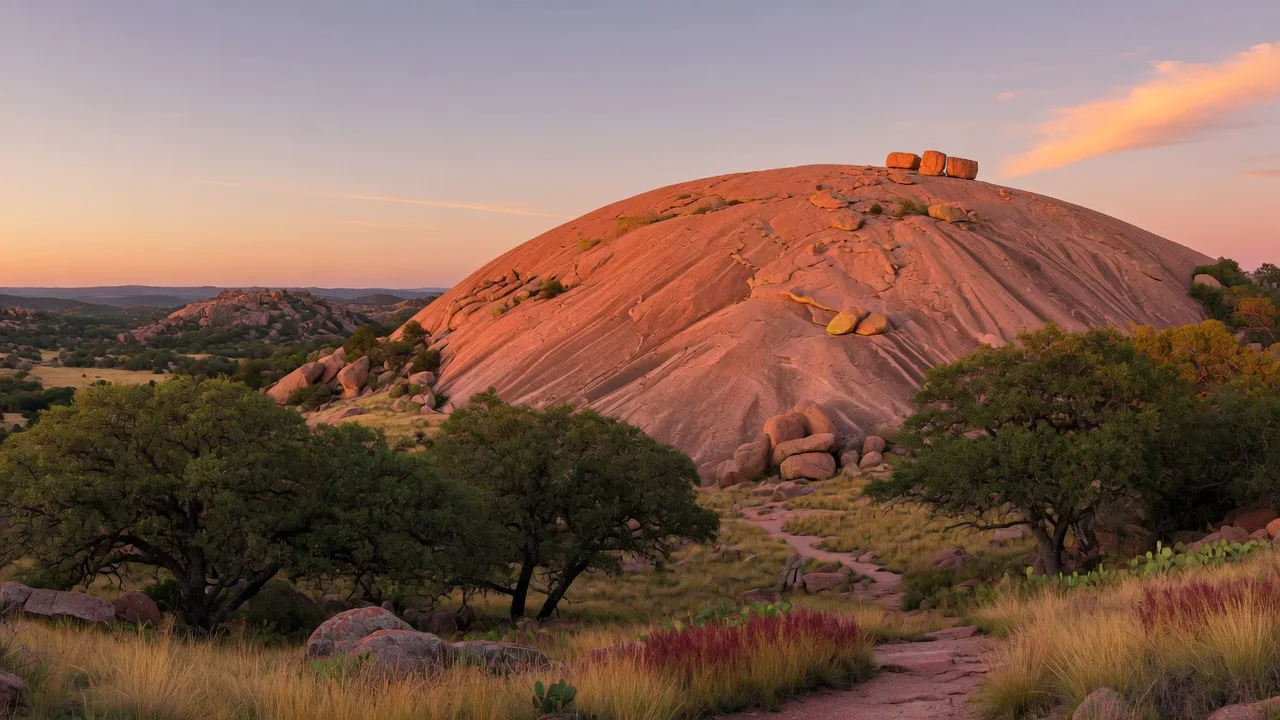
When California buyers who have spent weekends hiking in the Sierra Nevada, Joshua Tree, or the Pacific Coast ranges ask about outdoor recreation in the Texas Hill Country, one name comes up more than any other: Enchanted Rock. It is the place that Hill Country residents drive to for a Saturday morning summit hike, an afternoon of trad climbing, or an evening of dark-sky stargazing. It is also the place that people who have never been to central Texas recognize from photographs of the massive pink granite dome rising out of the Hill Country live oaks.
Enchanted Rock State Natural Area spans roughly 5,388 acres in northern Gillespie County, about 18 miles north of Fredericksburg on a two-lane Ranch Road. The centerpiece is the dome itself — a pink granite exfoliation batholith formed roughly 1.1 billion years ago during the Precambrian Era, exposed by erosion over hundreds of millions of years. It rises 425 feet above the surrounding terrain to a summit elevation of 1,825 feet above sea level. It is the largest pink granite monadnock in the United States.
This guide covers everything California relocators need to know to plan their first visit: the hiking trails, the Summit Trail, rock climbing routes, camping options, how to get in (including the reservation system), distances from Hill Country communities, costs, and practical tips for making the most of a day or weekend.
Enchanted Rock at a Glance
| Detail | Value |
|---|---|
| Total acreage | ~5,388 acres (after 2024 expansion adding 3,700+ acres) |
| Dome height | 425 feet above surrounding terrain |
| Summit elevation | 1,825 feet above sea level |
| Distance from Boerne | 44 miles (roughly 50 minutes via I-10 and US-87) |
| Distance from Fair Oaks Ranch | ~50 miles (55-60 minutes) |
| Distance from downtown San Antonio | ~58 miles (roughly 75 minutes) |
| Day-use entrance fee | $8 per person (ages 13 and older); 12 and under free |
| Gate hours | 6:30 AM to 8:00 PM (office opens at 8:30 AM) |
| Designations | National Natural Landmark (1971), National Register of Historic Places, International Dark Sky Park (2014) |
Hiking Trails: Over 11 Miles of Routes
Enchanted Rock has more than 11 miles of hiking trails spanning easy interpretive loops to the strenuous climb up the dome. The trails are well marked and maintained. Below are the primary routes, organized by difficulty.
Summit Trail
| Parameter | Detail |
|---|---|
| Distance | 0.8 miles (one way) |
| Elevation gain | 425 feet |
| Difficulty | Moderate to challenging |
| Notes | Most popular trail. Dogs not permitted. Can close in wet weather for safety. No shade on the dome surface. |
The Summit Trail is what most people come for. It climbs from the base parking area across the bare granite face to the highest point on the dome. The climb is steep in sections and requires careful footing on the exfoliated granite, especially on the descent. On clear days the summit views extend for miles across the Hill Country. Plan for 45 minutes to an hour up, 30 minutes down, plus time at the top.
Additional Trails
| Trail | Distance | Difficulty | Highlights |
|---|---|---|---|
| Enchanted Rock Loop Trail | 5.2 miles | Moderate | Circles the base of Enchanted Rock and Little Rock |
| Inner Loop (Summit + Echo Canyon + Base + Turkey Pass) | 3.1 miles | Moderate | Combines multiple trails through Echo Canyon |
| Moss Lake via Echo Canyon Trail | 3.1 miles | Moderate | Leads to Moss Lake, a seasonal stock tank popular for fishing |
| Short Loop | 1.1 miles | Easy | Good option for families with younger children |
| Interpretive Loop Trail | 0.5 miles | Easy | Features native plants of the Llano Uplift near the parking area |
Rock Climbing at Enchanted Rock
Enchanted Rock is the primary traditional climbing destination in the Texas Hill Country. The dome offers multiple crack and face climbs of varying difficulty, mostly on the north and east faces. Grades range from 5.5 (beginners with experience) through 5.12 (advanced). Most climbs are trad (traditional) lead climbs requiring a rack of protection — there are no bolted sport routes on the main dome. The granite is solid and textured, offering good friction on slab sections. Bouldering is available around the base of the dome and at Little Rock.
The climbing season runs from October through May. Summer surface temperatures on the exposed granite can exceed 110 degrees, making climbing unsafe and unpleasant. Winter temperatures in the 40s to 60s are common and ideal. The park requires climbers to sign in at the visitor center and follow designated climbing area rules.
For California climbers accustomed to Yosemite, the Sierra, or Joshua Tree, Enchanted Rock offers a different but legitimate granite climbing experience. The scale is smaller — the tallest climbs are roughly 200 to 300 feet — but the quality of the rock and the variety of crack systems make it a worthwhile destination. The closest climbing gyms for indoor training are in San Antonio (Armadillo Boulders, 8 miles from downtown) and Austin (Austin Bouldering Project, Crux Climbing Center).
Climbing at Enchanted Rock
All climbers must sign in at park headquarters. The Summit Trail is closed during wet conditions. No dogs on the Summit Trail. Dogs are permitted on the Loop Trail and in the campground. Helmets recommended on all climbs.
Dark Sky Stargazing
In 2014, Enchanted Rock was designated an International Dark Sky Park by the International Dark-Sky Association. It is one of only a handful of certified dark sky parks in Texas, and the closest to San Antonio and the Hill Country corridor. The designation recognizes the park's efforts to minimize light pollution and preserve the natural night environment.
For California relocators accustomed to the light pollution of the Bay Area, Los Angeles, or Sacramento metro areas, the difference is striking. On a clear new-moon night, the Milky Way is visible to the naked eye across the dome. The park occasionally hosts public stargazing events with telescopes and park ranger interpretation. For the best viewing, plan a visit during a new moon phase in fall, winter, or early spring, when the nights are longer and the air is clearer.
The Loop Trail remains open until 10:00 PM for nighttime hiking. Night photography of the dome under stars is a popular activity. Bring a red-lens headlamp to preserve night vision and keep artificial light to a minimum.
Camping and Overnight Stays
Enchanted Rock offers three camping options, none of which allow RVs or trailers. The park is primarily a walk-in camping experience, which suits the natural setting but requires planning.
Walk-In Tent Camping (35 sites)
The main campground consists of 35 walk-in tent sites located 100 to 200 yards from the parking area and restrooms. Each site has a picnic table, outdoor grill, fire ring, and access to nearby water faucets. Some sites have shade shelters. A shower building serves the walk-in campground. These sites are the most accessible option and book quickly.
Primitive Backcountry Camping (20 sites)
Two backcountry zones offer more remote camping. Moss Lake (8 sites) and Walnut Springs (12 sites) require a 1 to 3 mile hike over rugged terrain. These sites have no water, no electricity, and no facilities beyond a fire ring. Backcountry campers must pack in all water and supplies.
Group Camping
A group camping area with dedicated parking and a private camping area (about 0.25 mile hike from parking) is available for organized groups. Reservations are required and can be made through the Texas State Parks reservation system.
All campsites require reservations, which can be booked up to five months in advance through the Texas State Parks reservation system (reserve.txparks.it.texas.gov). Weekend and holiday sites at Enchanted Rock frequently sell out during peak season, particularly October through May. If you plan a weekend trip, book as far ahead as possible.
How to Get In: Reservations and Gate Policy
Enchanted Rock is one of the most popular state parks in Texas, and its gate frequently reaches capacity. The park has a reservation system that California visitors should understand before driving out.
- Reservations are required on weekends, school breaks, and state holidays. Day passes can be purchased online up to 30 days in advance through the Texas State Parks reservation portal.
- Weekday visits without a reservation are accepted on a first-come, first-served basis until capacity is reached. But the park often reaches capacity on weekdays as well, especially during spring wildflower season (March-April) and fall (October-November).
- The park gate opens at 6:30 AM. Arriving early is the single most effective strategy for securing entry on busy days. On weekends, the parking lot is often full by 9:00 AM.
- Day-use fee is $8 per person for ages 13 and older. Children 12 and under enter free. Texas State Parks Pass holders receive free entry for the pass holder and accompanying guests (up to one vehicle).
- The Summit Trail is closed during wet or icy conditions. Check the park's alert page before driving out if rain is in the forecast. The granite dome becomes dangerously slippery when wet.
Practical Tips for First-Time Visitors
Based on what California relocators most often ask about, here are the practical details that make the difference between a good visit and a frustrated one.
When to Visit
The best months are October through May. Summer daytime temperatures above 95 degrees make the summit hike uncomfortable and potentially dangerous — there is zero shade on the dome surface, and the granite radiates heat. Spring (March-April) offers wildflowers including bluebonnets and Indian paintbrush. Fall (October-November) offers the most comfortable hiking temperatures. Winter (December-February) can be cold at the summit but the hiking is excellent with significantly smaller crowds on weekdays.
What to Bring
- Water. A minimum of one liter per person per hour of hiking. There is no water on the trails or the summit. Carry more than you think you need.
- Sun protection. Hat, sunscreen, and sunglasses. The granite reflects sunlight from below, increasing exposure.
- Sturdy footwear. The granite surface is textured but steep. Running shoes with good traction are the minimum. Hiking boots are better.
- Layers. Summit temperatures can be 10 to 15 degrees cooler than the base, and wind speeds are higher on the dome.
- Red-lens headlamp if you plan to stay past sunset.
What Not to Bring
- Dogs on the Summit Trail. Dogs are not permitted on the dome. They are allowed in the campground, picnic areas, and on the Loop Trail (must be leashed at all times).
- Glass containers. Not permitted anywhere in the park.
- Fireworks or firearms. Prohibited in all Texas State Parks.
Nearby Towns and Amenities
The closest town of significant size is Fredericksburg, 18 miles south on Ranch Road 965. Fredericksburg has grocery stores, restaurants, gas stations, breweries, and wineries. The park has a camp store with basic supplies but does not have a full-service restaurant. Fill your tank and buy supplies in Fredericksburg before heading north to the park. For dining and wine country guidance, see the Hill Country Wineries Guide and the Hill Country Dining Guide.
Geology and History: A Billion-Year-Old Landmark
Enchanted Rock is a pink granite batholith — a massive body of igneous rock that formed when molten magma intruded deep within the Earth's crust during the Grenville orogeny, a major mountain-building event roughly 1.1 billion years ago. Over hundreds of millions of years, erosion stripped away the overlying rock, exposing the dome as part of the Llano Uplift, a geological region in central Texas where ancient Precambrian rocks are exposed at the surface.
The dome is a classic exfoliation feature — layers of granite peel away in curved sheets as the rock expands and contracts with temperature changes. This creates the characteristic smooth, rounded appearance and the slab-like surfaces that climbers seek. The exfoliation also creates seasonal rockfall hazards, which is one reason the summit trail closes during wet weather.
Archaeological evidence shows human habitation at the site dating back at least 10,000 years. The Tonkawa, Apache, and Comanche people all have historical ties to the area. The name "Enchanted Rock" comes from Tonkawa and Comanche oral traditions describing mysterious lights and sounds — likely caused by the moon's reflection on granite seeps and the thermal contraction of the rock at night.
The site was designated a National Natural Landmark in 1971 and placed on the National Register of Historic Places as an archaeological district with more than 400 documented sites. In 1978, the property was saved from commercial development through the efforts of Lady Bird Johnson, The Nature Conservancy, and the Texas Parks and Wildlife Department. The state natural area opened in 1984 and has expanded significantly since, including a 3,700+ acre acquisition in 2024.
Why Enchanted Rock Matters for California Relocators
For California buyers evaluating a move to the Texas Hill Country, Enchanted Rock answers a specific question: does this region have the kind of dramatic, accessible, year-round outdoor recreation that makes living here feel like more than a compromise? The answer is yes. Enchanted Rock is not Yosemite. It is not the Sierra Nevada. But it is a legitimate granite dome with real hiking, real climbing, and real dark-sky stargazing — and it is 44 miles from Boerne.
The quality of life in the Hill Country includes the ability to leave your house on a Saturday morning, drive 50 minutes, hike to the top of a billion-year-old granite dome, look out over live oaks and limestone hills to the horizon, and be home by lunch. That is not an exaggeration. It is a standard weekend activity for people who live here.
For a broader overview of outdoor recreation in the region, see our state and local parks guide. For specific activities like mountain biking and disc golf, see the active outdoor recreation guide. And for a comparison of Hill Country communities and which puts you closest to the best outdoor access, review the city comparison guide.

Written by
Bill Ross
Hill Country Homesteads Group, brokered by KW Boerne
Bill Ross is a Texas real estate agent with nearly four decades in high-tech sales and a network of 1,100+ California real estate agents for coordinated cross-state transactions. Featured in national coverage discussing his family's relocation from Silicon Valley to the Texas Hill Country. He covers the Texas Hill Country including Boerne, Fair Oaks Ranch, San Antonio, and surrounding communities.
Related Guides
State and Local Parks Near Boerne
Guadalupe River State Park, Government Canyon, Boerne City Park, Phil Hardberger Park, and more with distances, fees, and trail details.
Active Outdoor Recreation in the Hill Country
Mountain biking, rock climbing, road cycling, trail running, and disc golf — trail data, distances, and costs.
Guadalupe River Recreation Guide
Tubing, fishing, kayaking, and swimming access on the Hill Country's defining waterway.
What to Expect: Climate and Lifestyle
Seasonal specifics, cultural adjustment, and what daily life feels like in the Hill Country.
Sources
- Enchanted Rock State Natural Area — fees, trails, camping, and regulations — Texas Parks and Wildlife Department (TPWD). tpwd.texas.gov
- Enchanted Rock entrance fees and reservation system — TPWD, Entrance Fees page. tpwd.texas.gov
- Enchanted Rock campsites and group facilities — TPWD, Campsites page. tpwd.texas.gov
- Enchanted Rock park expansion (2024) — TPWD, Development page. tpwd.texas.gov
- Enchanted Rock geology and dark sky designation — Texas State Parks Reserve America / Wikipedia. wikipedia.org
- Enchanted Rock National Natural Landmark and conservation history — The Nature Conservancy. nature.org
- Enchanted Rock hiking trails and distances — AllTrails. alltrails.com
- Enchanted Rock visitor guide — Visit Fredericksburg TX. visitfredericksburgtx.com
Last reviewed: July 2026. Sources verified for accuracy.