
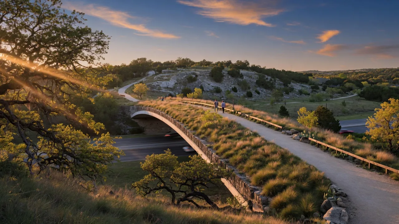
When California relocators visit San Antonio for the first time, they often ask where they can walk, run, or take their dog that feels like a real park -- not just a manicured lawn with a playground. Phil Hardberger Park is the answer. It is a 330-acre urban nature park on the city's north side that combines engineered ecological infrastructure with the kind of accessible daily recreation that Hill Country residents use year-round.
The park is named for Phil Hardberger, who served as San Antonio's mayor from 2005 to 2009 and led the city's purchase of the 311-acre Voelcker family dairy farm for public parkland. The acquisition was part of a $550 million bond program approved by voters in 2007, of which Hardberger Park was considered the signature project. The park opened in May 2010 and has expanded significantly since, including the completion of the Robert L.B. Tobin Land Bridge in December 2020 -- a $23 million structure that is the first mixed-use wildlife crossing built in any American city park.
This guide covers everything California relocators need to know about Phil Hardberger Park: the Land Bridge, the trail network, dog parks, the Urban Ecology Center, distances from Hill Country communities, hours, and how this park fits into the broader outdoor lifestyle of the region.
Phil Hardberger Park at a Glance
| Detail | Value |
|---|---|
| Total acreage | 330+ acres |
| Total trail miles | 8 miles |
| Land Bridge dimensions | 189 feet long, 150 feet wide |
| Land Bridge cost | $23 million |
| Distance from Boerne | 35-40 minutes (via I-10 East and Blanco Road) |
| Distance from Fair Oaks Ranch | ~30 minutes |
| Distance from downtown San Antonio | ~15-20 minutes |
| Day-use fee | Free |
| Park hours | Daily, 5 a.m. to 10 p.m. |
| Address | 13203 Blanco Road, San Antonio, TX 78216 |
The Robert L.B. Tobin Land Bridge
The Land Bridge is the centerpiece of Phil Hardberger Park and the feature that makes this park genuinely distinctive. It is a 189-foot-long, 150-foot-wide vegetated bridge that spans Wurzbach Parkway, connecting the two halves of the park. It is the first wildlife crossing in the United States designed for both wildlife and human use within an urban park.
The bridge opened in December 2020 after two years of construction. The project cost $23 million and was funded by a combination of city bond funds and private donations, including a lead gift from the Tobin Foundation. The bridge is planted with native grasses, wildflowers, and live oaks, creating a continuous habitat corridor that deer, foxes, coyotes, and smaller wildlife use to move between the east and west sides of the park without crossing traffic below.
Eight-foot-tall corten steel walls line both sides of the bridge to dampen road noise and shield wildlife from headlights. The bridge surface is a wide, gently graded path that pedestrians, joggers, and cyclists share. From above, the bridge disappears into the landscape -- the vegetation has grown in sufficiently that a casual visitor walking the Savanna Loop might not realize they are crossing a highway.
For California relocators who are accustomed to wildlife corridors in the Sierra Nevada or the undercrossings on Highway 17 in the Santa Cruz Mountains, the Land Bridge is a different scale and purpose. It is not a remote crossing in a national forest. It is a deliberate piece of urban ecological infrastructure designed to prove that cities and wildlife habitat can coexist. It is one of the most photographed features in the San Antonio park system, and it is a legitimate point of civic pride for residents who value green space in a growing city.
Trail Network: 8 Miles Across Two Park Halves
Phil Hardberger Park is divided by Wurzbach Parkway into an east side (Blanco Road entrance) and a west side (NW Military Highway entrance). The Land Bridge connects the two. The combined trail network covers 8 miles, with surfaces ranging from paved and decomposed granite to natural terrain.
Trail Details
| Trail | Distance | Surface | Highlights |
|---|---|---|---|
| Savanna Loop | 1.84 miles | Unpaved | Crosses the Land Bridge; open grassland habitat with wildflowers |
| Oak Loop | 0.84 miles | Unpaved | Shaded loop through mature live oak woodland |
| Water Loop | 1.0 mile | Decomposed granite / concrete | Circles the restored wetland pond; connects to Salado Creek Greenway |
| Geology Trail | 0.8 miles | Natural surface | Connects Water Loop to Salado Greenway; limestone geology features |
| Skywalk | Elevated section | Wooden boardwalk | Ascends 20 feet into the live oak canopy; accessed from Water Loop |
The Water Loop and Geology Trails together cover 2.5 miles and connect directly to the Salado Creek Greenway, a regional trail system that extends approximately 40 miles through north San Antonio. This connection means that a runner or cyclist at Hardberger Park can access a continuous trail network stretching across multiple neighborhoods.
The Skywalk is worth calling out separately. It is a raised wooden boardwalk that climbs 20 feet into the canopy of a mature live oak grove, giving visitors an elevated perspective of the woodland. It is a short detour from the Water Loop but adds a dimension most urban parks do not offer -- a view of the tree canopy from above, accessible to anyone who can walk a gentle ramp.
Dog Parks, Playgrounds, and Amenities
Phil Hardberger Park is one of the more amenity-rich parks in the San Antonio system, particularly for families and dog owners.
Dog Parks
The park has two separate dog parks -- one on the east side (Blanco Road) and one on the west side (NW Military Highway). Each is a fenced, off-leash area with separate sections for large and small dogs. Water stations, waste bags, and seating are provided. For California relocators accustomed to the crowded dog parks of San Francisco, Los Angeles, or San Diego, the Hardberger Park dog parks are notably spacious and less densely used.
Playgrounds and Family Amenities
There are two playscapes -- one on each side of the park -- plus a Children's Nature Play Area that uses natural materials like logs, boulders, and native plants instead of plastic play structures. The park also has two basketball courts (west side), multiple picnic pavilions with extra-long tables and built-in BBQ pits, and open fields suitable for soccer, frisbee, or informal games.
Urban Ecology Center and Salado Outdoor Classroom
The Urban Ecology Center on the east side of the park houses educational exhibits, restrooms, and staff offices. The Salado Outdoor Classroom is an adjacent open-air pavilion used for nature programs, school field trips, and community events. Both facilities offer free public WiFi. The center hosts regular programs on native plants, bird identification, and the park's restoration projects.
Restored Wetland and Wildlife Viewing
The Water Loop trail circles a constructed wetland that was restored as part of the park's original design. The wetland filters stormwater runoff, provides habitat for waterfowl and wading birds, and serves as a natural classroom for water quality education. Visitors regularly see great blue herons, egrets, red-eared slider turtles, and dragonflies around the pond. The wetland is one of the most consistently productive birding spots in north San Antonio.
From Dairy Farm to Urban Park
Before it was a park, the 311-acre property was the Voelcker family dairy farm, which operated from the 1940s through the early 2000s. The property includes a preserved 1830s Texas stone house -- one of the oldest standing structures in Bexar County -- which now serves as a historic interpretive site within the park.
In 2006-2007, Mayor Phil Hardberger made the acquisition of the Voelcker property a centerpiece of his administration. The city purchased the land using bond funds approved by San Antonio voters in May 2007 as part of a $550 million bond program. At the time, it was the most expensive single park acquisition in the city's history, and it was not universally popular -- some residents argued the money should have gone to other infrastructure needs. Hardberger's position was that a city growing as fast as San Antonio needed to secure significant green space before development made it impossible. Time has proven him right. The property today would cost multiples of what the city paid, and the surrounding development has only increased the value of protected open space.
The park opened to the public in May 2010. The Land Bridge was added a decade later, cementing the park's reputation as one of the most innovative urban parks in Texas. The Phil Hardberger Park Conservancy, a nonprofit foundation, supports ongoing maintenance, programming, and capital improvements.
How Hardberger Park Compares to Urban Parks Californians Know
California relocators evaluating the Hill Country's outdoor lifestyle often want to understand what the daily park experience is like -- not just the showpiece state parks, but the parks you visit on a Tuesday evening or a Saturday morning with your dog and kids.
Phil Hardberger Park fills a similar role to Golden Gate Park in San Francisco or Griffith Park in Los Angeles, but at a different scale and with a different character. It is not a destination with museums, gardens, and a concert venue. It is a neighborhood-scale nature preserve that happens to be large enough to get lost in. The trail surfaces are not all paved. The vegetation is intentional habitat restoration, not ornamental landscaping. The park feels like a slice of the Hill Country that was preserved inside the city limits -- which is exactly what it is.
What distinguishes Hardberger Park from comparable California urban parks is the Land Bridge and the ecological restoration philosophy. Golden Gate Park is a masterpiece of 19th-century landscape architecture. Griffith Park is a rugged mountain park dropped into a city. Hardberger Park is a 21st-century urban nature preserve designed around habitat connectivity, stormwater management, and native ecosystems. It represents a different generation of park design.
The other practical difference is crowding. Golden Gate Park receives approximately 24 million visitors per year. Griffith Park receives roughly 10 million. Phil Hardberger Park sees a fraction of that -- enough for the trails to feel pleasantly used but never congested, even on weekends. For California relocators accustomed to circling for parking at popular urban parks, Hardberger Park is a relief.
Practical Tips for First-Time Visitors
Which Entrance to Use
The park has two main entrances. The east entrance at 13203 Blanco Road (north of Wurzbach Parkway) gives access to the Urban Ecology Center, the Savanna Loop trailhead, the Land Bridge, the east-side dog park, and the larger playscape. The west entrance at 1400 NW Military Highway (south of Wurzbach) provides access to the Water Loop, the Skywalk, the west-side dog park, basketball courts, and additional picnic areas. If you want to experience the Land Bridge, enter from the Blanco Road side.
Best Times to Visit
The park is open daily from 5 a.m. to 10 p.m. Early morning (6 a.m. to 8 a.m.) is popular with runners and dog walkers, and the light is excellent for photography. Late afternoon from 4 p.m. to sunset is the busiest period, with families and casual walkers. Summer evenings are particularly pleasant because the park's trees and wetland create a cooling effect. The park is considerably less crowded on weekdays than on weekends. For California relocators accustomed to the early-morning hiking culture of the West Coast, 6 a.m. at Hardberger Park will feel familiar.
Parking
Both entrances have paved parking lots. The Blanco Road lot is larger and fills first on weekends. There is overflow parking along the access roads. The lots are well lit and generally safe, but as with any urban park, do not leave valuables visible in your vehicle.
What to Bring
- Water. There are water fountains at the Urban Ecology Center and near the playscapes, but it is wise to bring your own bottle, especially on warm days.
- Sun protection. The Savanna Loop has limited shade. The Oak Loop and Water Loop are more shaded. Summer sun in San Antonio is intense even in the morning.
- Dog leash and bags. Dogs must be leashed on all trails. Off-leash access is limited to the fenced dog parks.
- Insect repellent. Mosquitoes are present near the wetland, particularly around dawn and dusk from spring through fall.
Connecting to the Greenway
The Salado Creek Greenway connects directly to the Water Loop trail, offering access to approximately 40 miles of additional trails heading south through north San Antonio. This connection makes Hardberger Park a trailhead for longer runs and rides rather than just a destination. A round-trip from the park south to the San Antonio River eventually connects to the Mission Reach trail system -- a total of roughly 20 miles one way for ambitious runners and cyclists.
Why Hardberger Park Matters for California Relocators
For California buyers evaluating where to live in the Hill Country, Phil Hardberger Park answers a practical question: what does daily outdoor access look like for someone who does not live in Boerne's historic district or on an acreage in Fair Oaks Ranch?
The answer is that San Antonio's north side -- roughly a 35- to 40-minute drive from Boerne and 30 minutes from Fair Oaks Ranch -- offers a 330-acre urban nature preserve with 8 miles of trails, a wildlife crossing that has been featured in national design publications, and a trail network that connects to 40 miles of greenway. And it is free.
For residents living in the northern San Antonio neighborhoods closest to the park -- Stone Oak, The Dominion, Rogers Ranch, and the 1604/281 corridor -- Hardberger Park functions as a backyard trail system. For Boerne and Fair Oaks Ranch residents, it is a weekend destination that combines the best elements of an urban park and a nature preserve, all within a reasonable drive.
The Land Bridge alone is worth the trip. It is the kind of feature that California relocators, accustomed to seeing innovative public infrastructure in Bay Area and LA parks, will appreciate as a genuinely forward-thinking investment in quality of life. That a mid-size Texas city committed $23 million to a wildlife crossing in an urban park says something about how San Antonio views green space and community investment.
For a broader overview of outdoor recreation options across the Hill Country, see our state and local parks guide. For information on the Guadalupe River and water-based recreation, see the Guadalupe River recreation guide. And for a full comparison of Hill Country communities and their access to parks and outdoor amenities, review the city comparison guide.
Written by
Bill Ross
Hill Country Homesteads Group, brokered by KW Boerne
Bill Ross is a Texas real estate agent with nearly four decades in high-tech sales and a network of 1,100+ California real estate agents for coordinated cross-state transactions. Featured in national coverage discussing his family's relocation from Silicon Valley to the Texas Hill Country. He covers the Texas Hill Country including Boerne, Fair Oaks Ranch, San Antonio, and surrounding communities.
Related Guides
State and Local Parks Near Boerne
Guadalupe River State Park, Government Canyon, Boerne City Park, Friedrich Wilderness Park, and more with distances, fees, and trail details.
Active Outdoor Recreation in the Hill Country
Mountain biking, rock climbing, road cycling, trail running, and disc golf with trail data, distances, and costs.
San Antonio Guide for California Relocators
Cultural institutions, dining, healthcare, sports, and urban amenities in the city behind Hill Country living.
Boerne vs Fair Oaks Ranch vs San Antonio
Compare Hill Country communities for families, retirees, and remote workers.
Sources
- Phil Hardberger Park overview, acreage, and hours — City of San Antonio Parks and Recreation. sanantonio.gov
- Park amenities: trails, dog parks, playgrounds, and facilities — Phil Hardberger Park Conservancy. philhardbergerpark.org
- Individual trail details and distances — Phil Hardberger Park Conservancy trail pages. philhardbergerpark.org
- Robert L.B. Tobin Land Bridge dimensions, cost, and design — Phil Hardberger Park Conservancy, Land Bridge page. philhardbergerpark.org
- Land Bridge construction timeline and funding — Wikipedia, Robert L.B. Tobin Land Bridge. wikipedia.org
- Park history and Voelcker farm acquisition — Wikipedia, Phil Hardberger Park. wikipedia.org
- SABO bond program and park acquisition details — San Antonio 2007 bond program. sanantonio.gov
- Salado Creek Greenway connection and trail system — City of San Antonio, Linear Creekway Parks. sanantonio.gov
Last reviewed: July 2026. Sources verified for accuracy.